Earth Observer
The Earth Observer newsletter.


Figure 5. Time series of CFC-11 equivalent emissions [top], Equivalent Effective Stratospheric Chlorine (EESC) [upper middle], annual global total ozone...

Figure 8. Ozone is a phytotoxic air pollutant that readily deposits to vegetation, including crops. Shown on the left panels...

Photo 3. [left] Ozonesonde launch demonstration during the Symposium at the University Memorial Center courtyard. [right] Demonstration of the stratospheric...

Figure 7. A graphical representation of tropospheric column ozone (TrOC) trends [parts-per-billion volume (ppbv)] defined from the surface to 300...

Figure 6. Asian Summer Monsoon Chemical and Climate Impact Project (ACCLIP) measurements show unprecedented concentrations of carbon monoxide (CO) [left]...

Figure 5. Time series of CFC-11 equivalent emissions [top], Equivalent Effective Stratospheric Chlorine (EESC) [upper middle], annual global total ozone...

Figure 4. Annual zonal mean concentration of black carbon in the atmosphere as a function of altitude and latitude simulated...

Figure 3. Simulated and observed bromoform (CHBr3) mixing ratios at the dynamical tropopause averaged over December 2015–February 2016, 180°W–30°E [left]...

Figure 2. A series of daily zonal averages between January 28 and April 22, 2022 from three satellites showing evaluation...

Figure 1. Annual mean anomalies of ozone (%) in the upper stratosphere [top three panels] near 42 km (26 mi)...

Photo 2. Sophie Godin-Beekmann presents awards during the QOS dinner. Valerie Thouret accepts the Farman award on behalf of Philippe...

Photo 2. Sophie Godin-Beekmann presents awards during the QOS dinner. Herman Smith receives the Farman award.

Photo 2. Sophie Godin-Beekmann presents awards during the QOS dinner. Luke Western accepts the Dobson Award.

Photo 2. Sophie Godin-Beekmann presents awards during the QOS dinner. Luke Western accepts the Dobson Award [top]; Herman Smith receives...

Photo 1. Group photo of 2024 Quadrennial Ozone Symposium in-person attendees at the University of Colorado, Boulder’s University Memorial Center.

Figure 4. Sentinel-2B image over the Baltimore-Washington area on April 7, 2022 [left]. Example true color images of top of...

Figure 3. Dense time series of Harmonized Landsat Sentinel-2 (HLS) data at 30-m (98-ft) resolution revealing winter and summer crops...

Figure 1. The Adaptation and Response in Drylands (ARID) experiment focuses on studying the characteristics of dryland ecosystems, such as...

Figure 2. The Ghana Climate Hazards Center Coupled Model Intercomparison Project (CMIP) Phase 6 climate projection dataset map of temperatures...

Photo 2. Some residents of a village neighboring the Dja reserve – part of the dense rain forests that form...

Photo. A group picture of meeting participants on the first day of the 2024 LCLUC meeting in Gaithersburg, MD.

Photo 2. Deployment of University of Pittsburgh’s new 12-channel TIR camera [far right] at Vulcano, Italy in June 2024 with...

Figure 3. Reflectance ratio of Landsat versus in situ, and ASTER versus in situ values.

Figure 2. Comparison of in situ derived radiances versus ASTER on-board radiances for 2024, determined at Lake Tahoe and Salton...

Figure 1. Nighttime thermal and daytime visible acquisitions of five different erupting volcanoes, captured in August and September 2024, triggered...

Photo 1. Several attendees at the 53rd ASTER Science Team workshop pose for a photo taken at Japan Space System’s...

Photo 4. [left to right] Amanda Armstrong, Elizabeth Hoy [both at Goddard Space Flight Center], and Timothy Assal [Bureau of...

Photo 3. Kira Sullivan-Wiley [Pew Institute] presents on co-production of knowledge during the first day's plenary session. Photo credit: AEOIP

Photo 2. Ann Arbor park staff conduct a prescribed fire demonstration for workshop participants during the Furstenberg Nature Area tour...

Photo. Participants at the 2024 AEIOP workshop. Photo credit: AEOIP

Figure 1. Optical [left and right] and thermal [right, overlay] images of participants at the 2024 AEIOP workshop obtained by...

Figure 3. Anomaly maps of merged tropospheric column ozone (TCO) satellite data [Dobson Units] for spring-summer 2020–2023. In this context,...


Clockwise from top left: Mike Ondrusek (NOAA), mission scientist of the R/V Shearwater, waves to the Navy Postgraduate School (NPS)...

Photo 2. The Twin Otter aircraft operated out of the Center for Interdisciplinary Remotely Piloted Aircraft Studies (CIRPAS) during the...

Photo 1. The Aura (formerly EOS CHEM) mission program scientist, project scientists (PS), and several of instrument principal investigators (PI)...

Figure. [Left] The GOES-19 images show the contiguous U.S. observed by each of the Advanced Baseline Imager’s (ABI) 16 channels...


Figure. Locations Green-Down observations being entered into the GLOBE database. Figure credit: GLOBE

Photo 7. At the Miami Executive Airfield, members of NASA’s BlueFlux airborne science team stand in front of the Beechcraft...

Photo 5. David Lagomasino holds a Russian peat auger containing a sample of Everglades peat. The primary source of the...

Figure 3. An example of flight paths from eight BlueFlux airborne deployments flown in April 2023. The flight paths are...

Figure 5. A map of the BlueFlux study region, showing mangrove extent (green) and the paths of tropical storms and...

Figure 4. Sample of methane flux upscaling, in which MODIS surface reflectance retrievals are used to predict CH4 flux for...

Photo 10. The Tamiami Trail Canal runs across the Florida Peninsula from west to east, towards a saltwater treatment facility...

Photo 9. The Blue Flux airborne science team collects flux measurements from 90m (300ft) above Florida’s mangrove forests. Photo credit:...

Photo 8. The CARAFE payload is responsible for taking readings of atmospheric CO2, CH4, and H2Ov levels using a wind...

Photo 7. At the Miami Executive Airfield, members of NASA’s BlueFlux airborne science team stand in front of the Beechcraft...

Photo 6. Mangroves are viviparous plants. Their propagules – or seedlings – germinate while still attached to their parent tree....

Photo 4 At SRS-6, an eddy covariance tower measures C02 and CH4 flux among a dense grove of red, black,...

Photo 3. Assistant professor David Lagomasino and Ph.D. candidate Daystar Babanawo [both from East Carolina University] explore the lower Everglades...

Photo 2: A mangrove ghost forest houses the remains of a once-thriving mangrove stand, preserving an image of Hurricane Irma’s...

Photo 1. A Mangrove stand lines the bank of Shark River, an Everglades distributary that carries water into the Gulf...

Figure 2. To directly measure the emission and sequestration rates of CO2 and CH4 between the atmosphere and Florida’s mangroves,...

Figure 1. A map of South Florida overlaying a true-color image captured by the Moderate Resolution Imaging Spectroradiometer (MODIS) instrument...

Figure 3. Anomaly maps of merged tropospheric column ozone (TCO) satellite data [Dobson Units] for spring-summer 2020–2023. In this context,...

Figure 1. An example of TROPOMI pixel nitrogen dioxide (NO2) observations over Europe on September 8, 2018 [top] and the...

Figure 7. Landsat Optical Land Imager (OLI) image obtained on October 17, 2021, over Saudi Arabia shows power plant exhaust,...

Figure 6. Methane plume map produced by SRON shows TROPOMI large methane (CH4) emissions plumes for the week of the...

Photo. Group photo of the in-person participants to the OMI–TROPOMI science team meeting. Photo credit: Shaun Bush/ACOM

Johan de Vries June 10, 1956 – May 8, 2024

Figure 5. Global gridded (0.10 x 0.10 ) composite map of Aerosol Layer Optical Centroid Height (AH) retrieved from TROPOMI...

Figure 4. OMI NO2 time series bridging the first GOME mission [which flew on the European Remote Sensing Satellite–2 (ERS–2)...

Figure 2. Reprocessed OMI records (from Collection 4) of monthly average aerosol optical depth (AOD) at 388nm derived from the...


A flash of lightning, and then—something else. High above a storm, a crimson figure blinks in and out of existence....

Soldering is an essential manufacturing step for joining electrical conductors. It involves the melting and solidification of materials, which can...

During its close flyby of Jupiter’s moon Io on December 30, 2023, NASA’s Juno spacecraft captured some of the most...

Sea ice is frozen seawater that floats in the ocean. This photo, taken from NASA’s Gulfstream V Research Aircraft on...

This face-on view of spiral galaxy NGC 628 is split diagonally, showing observations from the James Webb Space Telescope (JWST)...

The Solar Ultraviolet Imager (SUVI) instrument aboard the Geostationary Operational Environmental Satellites (GOES) West satellite observed a flurry of solar...

For the first time, astronomers have combined data from NASA’s Chandra X-ray Observatory and James Webb Space Telescope to study...

Every winter, a layer of carbon dioxide frost (dry ice) forms on the surface of Mars. At its greatest extent...

NASA’s Plankton, Aerosol, Cloud, ocean Ecosystem (PACE) satellite, launched on February 8, 2024, collects data on microscopic life in the...

As NASA prepares to return to the Moon, it is important to study the impacts of space radiation and other...

On its journey to the never-before-visited Trojan asteroids that share an orbit around the Sun with Jupiter, NASA’s Lucy spacecraft...

The strongest geomagnetic storm in over two decades dazzled scientists and skywatchers in May 2024. Overnight on May 10–11, an...

Photo 2. Montgomery County’s (Maryland) Georgian Forest Family Science, Technology, Engineering, and Math (STEM) Night. Shown here is a triptych...

Figure 3. Example of Global Precipitation Climatology Project (GPCP) Daily Climate Data Record (CDR) for January 28, 2018. GPCP incorporates...

Photo 3. The GPM Outreach Team engaging the public at Maryland Day 2023, hosted by the University of Maryland (UMD),...

Photo 1. The NASA S-Band Dual Polarimetric Radar (NPOL) deployed in central Iowa in support of the IFloodS field campaign...

Figure 7. Collage of GPM case study examples enabling societal applications, including weather forecasting, nowcasting of extremes, agricultural and drought...

Figure 6. GPM Applications icon highlights six thematic and primary societal application areas supported by GPM data: ecological management, water...

Figure 5. Schematic of GPM observed latent heating in convective cores (i.e., thunderstorms) relative to a larger thunderstorm complex (i.e.,...

Figure 4. Average rainfall patterns from 2014–2020 in January using the NASA Goddard Institute for Space Studies’ (GISS)- E3 climate...

Figure 2. Seasonal average cloud latent heating at a height of 6 km (~4 mi) derived from GSFC’s Goddard Convective–Stratiform...

Figure 1. Schematic diagram of the GPM Core Observatory's Dual-frequency Precipitation Radar (DPR) and GPM Microwave Imager (GMI) instruments. Figure...

Photo 11. A young Earth Day participant interacts with Ellen Gray [NASA GSFC—Earth Science News Team]. Photo credit: NASA

Photo 19. Dorian Janney [GSFC—GPM Outreach Specialist] engages visitors at the “Connect the Drops” station, where visitors learn how and...

Photo 18. Young attendees engage with the “Meteorite Map Challenge.” Photo credit: NASA

Photo 17. Young attendees engage with Valerie Casasanto [GSFC— Ice, Cloud, and land Elevation Satellite-2 (ICESat-2) Outreach Lead], who helps...

Photo 16. Student attendees make ultraviolet-bead bracelets and Helio Big Year buttons at the Heliophysics station. Photo credit: NASA

Photo 15. Students play a Global Ecosystem Dynamics Investigation (GEDI) Jeopardy game at the “GEDI Knights Measure Forests from Space”...

Photos 14. Students explore the Chesapeake Bay as seen by Landsat 8 with a large, vinyl floor mat. Photo credits:...

Photos 13. Ross Walter [GSFC—Data Visualizer and Animator, Landsat Outreach Team] engages with students at the “Viewing Earth From Above...

Photo 12. Jenny Mottar [NASA HQ—Art Director for the Science Mission Directorate] and Kevin Miller [GSFC—SSO Senior Graphic Designer] hand...

Photo 10. [Left to right] Faith McKie [Acting NASA Press Secretary], Bill Nelson, Karen St. Germain, and Tom Wagner [Associate...

Photo 9. NASA Administrator Bill Nelson [center, rear] spent time circulating among the NASA Earth Day hands-on activities. Here, he...

Photos 6–7. Former NASA astronaut Paul Richards takes audience questions at the NASA Earth Day event. Photo credits: NASA

Photo 8. Karen St. Germain [NASA Headquarters—Director of NASA’s Earth Science Division] provided remarks and answered student questions in the...

Photos 6–7. Former NASA astronaut Paul Richards takes audience questions at the NASA Earth Day event. Photo credits: NASA

Photo 5. Trena Ferrell [GSFC—Earth Science Education and Public Outreach Lead] welcomed student attendees to the Earth Day event. Photo...

Figure 1. Earth Day Activity Passport. Figure credit: NASA

Photo 4. Mark Subbarao [GSFC—Scientific Visualization Studio Lead] engages attendees with NASA science in front of the EIC Hyperwall. Photo...

Photos 1–3. Student attendees at the Earth Information Center (EIC) interactive exhibit. Photo credits: NASA

Photos 1–3. Student attendees at the Earth Information Center (EIC) interactive exhibit. Photo credits: NASA

Photos 1–3. Student attendees at the Earth Information Center (EIC) interactive exhibit. Photo credits: NASA

Photo. Young attendees pose in front of the NASA Worm at the Earth Day celebration at NASA HQ. Photo credit:...


Animation. OMI data show changes in average levels of NO2 from March 20 to May 20 for each year from...
Figure 2. The evolution of MLS water vapor anomalies (deviations from the baseline 2005–2021 climatology) from January 2019 through December...

Figure 1. An artist’s representation of the Aura satellite in orbit around the Earth. Image credit: NASA

Figure 4. The Agência Nacional de Águas e Saneamento Básico’s (ANA) [Brazilian National Water and Sanitation Agency] SWOT Early Adopter...

Figure 3. Both these maps show the root mean square (RMS) error in the SWOT 21-day phase data in sea...

Figure 2. Altimetry data collected over calibration/validation (Cal/Val) sites using traditional nadir altimeter data only [left], a combination of traditional...

Figure 1. Forty SWOT Early Adopter (EA) teams span the globe with a wide range of operational and applied science...

Figure 10. Digital Elevation Model output before and after Hurricane Michael in Florida, October 2018.

Figure 9. Illustration of the ATL18 canopy height product at 1 km (~0.6 mi) spatial resolution at the global scale....

Figure 11. Bathymetry data from ICESat-2 [shown below] have been used across a wide variety of morphologies [some of which...

Figure 8. NASA’s Global Learning and observations to benefit the Environment (GLOBE) has developed an app called GLOBE Trees that...

Figure 7. Searching ICESat-2 tracks in OpenAltimetry, a map-based data visualization and discovery tool for altimetry data. Figure credit: Mikala...

Figure 6. The Science Impact Framework, which allows the impact of scientific work to be quantified and to determine if...

Figure 5. Strategies to extend ICESat-2 to new communities through activities and trainings such as those hosted by the Applied...

Figure 4. Near real-time active fire mapping as well as air quality monitoring and forecasting are available via NASA’s Fire...

Figure 3. Graphic showing the different levels of data available from the NASA Ice, Cloud, and land Elevation Satellite-2 (ICESat-2)...

Figure 2. A ‘donut’ plot showing the proportion of ICESat-2 Applications Workshop attendees identified by institution. This information was provided...

Figure 1. A word cloud designed to highlight terms that occur most frequently in all ICESat-2 publications since 2018. The...

Photo 10. Ellen Gray [GSFC/KBR—Senior Outreach Specialist] engaging attendees in Kerrville, TX with various NASA Science outreach materials. Photo credit:...

Photo 9. Steve Graham, Dalia Kirshenblat, Danielle Kirshenblat, and attendees as totality begins at approximately 3:13 PM EDT. Photo credit:...

Photo 8. Dalia Kirshenblat and Danielle Kirshenblat watching the eclipse begin at approximately 2:00 PM EDT. Photo credit: NASA

Photo 7. Steve Graham [GSFC/GST—Principal Outreach and Exhibits Specialist], Dalia Kirshenblat, and Danielle Kirshenblat [Space Telescope Science Institute (STScI)—Video Media...

Movie. Timelapse of the eclipse’s totality in Cleveland, OH. Photo credit: Danielle Kirshenblat
Photo 6. Jack Kaye [NASA HQ—Associate Director for Research, Earth Science Division (ESD)] hands out eclipse posters and other outreach...

Photo 5. SSO staff member Dalia Kirshenblat [NASA’s Goddard Space Flight Center (GSFC)/Global Science and Technology Inc.—Science Writer and Outreach...

Photo 4. Totality in Houlton, Maine. Photo credit: Zoe Jenkins

Photo 3. NASA Eclipse celebration at the sunspot in Houlton, Maine. Photo credit: Zoe Jenkins [NASA Headquarters (HQ)/ASRC Federal —...

Photo 2. Solar prominence [lower right of the solar disc] seen during totality in Cleveland, OH. Photo credit: GRC

Photo 1. The moment of totality in Cleveland, OH. Photo credit: GRC

Figure 3. Descriptions of each outreach activity stationed at individual tents over the three-day festival. Figure credit: GRC

Figure 3. Descriptions of each outreach activity stationed at individual tents over the three-day festival. Figure credit: GRC

Figure 2. Image of the “NASA Village” at the Eclipse festival in Cleveland, OH, hosted by GRC. Figure credit: GRC

Figure 1. The total solar eclipse was visible along a narrow track stretching from Texas to Maine on April 8,...

Credit: NASA’s Glenn Research Center (GRC)

Photo 15. Pilots prepare for the 2024 total solar eclipse experiments on WB-57 jets on April 8, 2024, at Ellington...

Photo 14. The third rocket from the APEP mission leaves the launch pad during the October 2023 annular eclipse. Photo...

Photo 13. [left to right] Nicola Fox [NASA HQ—Associate Administrator for the Science Mission Directorate (SMD)], Alex Lockwood [NASA HQ—Strategic...

Photo 12. Astronaut Reid Wiseman speaks at a NASA broadcast in Kerrville, TX. Photo credit: NASA

Photo 11. NASA Astronaut Reid Wiseman poses with a potential future astronaut and attendee at the Eclipse event in Kerrville,...

Main Banner Background Image of the Atchafalaya Delta in Louisiana, taken by Landsat 8 on Dec. 1, 2016. This false-color...


Figure. The day-night band on Visible Infrared Imaging Radiometer Suite (VIIRS) captured this image of the aurora borealis that occurred...


Figure 7. The CERES Earth Radiation Budget (ERB) climate data record shows a positive trend for the absorbed solar radiation...

Figure 1. The Total Solar Irradiance (TSI) composite record spans almost five decades and includes measurements from 13 different instruments...

Photo. Attendees at the 2023 Sun–Climate Symposium in Flagstaff, AZ. Photo credit: Kelly Boden/LASP

Map and photo credit: Mark Nebel/NPS

Figure 8. The San Fernando Observatory (SFO) [left] has been making visible [middle] and near ultraviolet (NUV) [right] solar images...

Figure 6. The sunspot number progression (black) during solar cycle 25 is higher than predicted (red). The original NASA–NOAA panel...

Figure 5. The albedo differences between the visible and near-infrared bands are shown for the southern hemisphere (red line) and...

Figure 4. The rainfall amount has shifted over the past fifty years (red is less and blue is more) with...

Figure 3. Illustration of an exoplanet transit that will occult a starspot. The transit light curve can provide information about...

Figure 2. The solar spectral irradiance (SSI) variability from TSIS-1 SIM is compared to the total solar irradiance (TSI) variability...

Figure 8. PAs effectively preserve additional AGC across continents and biomes, with forest biomes dominating the global signal, particularly in...


Figure 2. Daytime variability of the median liquid cloud optical thickness over ocean for different seasons of the year derived...

Figure 1. Sun-Earth-Vehicle (SEV) angle (red curve) and the distance between Earth and the DSCOVR satellite (blue curve) versus time...


Photo: Pictured here are the in-person attendees of the 2023 GRACE-FO Science Team. Another 52 people participated online. Image credit:...

Figure 1. The top row of maps show estimates of individual components of the observed sea level trend in the...
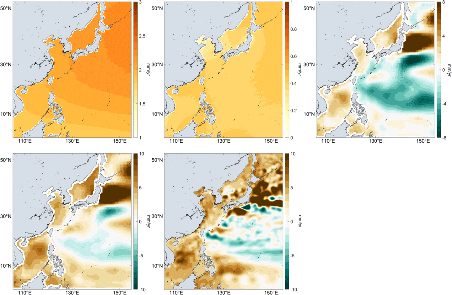
Figure 6. [Top] Average lidar canopy height at 0.01° resolution in. computed by gridding both GEDI and ICESat-2 together, and...

Photo. GEDI Science Team meeting in-person and virtual attendees. Photo credit: Talia Schwelling

Figure 9. Forest biomass estimates, in the format of Intergovernmental Panel on Climate Change (IPCC) Tier 1 values from NASA...

Figure 8. The GEDI-domain protected areas cover a range of biomes. Figure credit: Laura Duncanson/published in a 2023 paper in...

Figure 7. [Top] Protected areas (Pas) such as national parks can reduce habitat loss and degradation (from logging) and extractive...

Figure 5. Female Downy Woodpecker with tree cavity in which other organisms may use in the future for habitat. Woodpecker...

Figure 4. Gridded mean aboveground biomass density [top] and standard error of the mean [bottom] from Version 2.1 of the...

Figure 3. Salar de Uyuni, the world's largest salt flat as seen from the International Space Station. Figure credit: Samantha...

Figure 2. NASA GEDI mission move from EFU-6 to EFU-7 on the ISS on 17 March 2023. GEDI was in...

Figure 2. NASA GEDI mission move from EFU-6 to EFU-7 on the ISS on 17 March 2023. GEDI was in...

Figure 1. Country-wide estimates of total aboveground biomass (GEDI_L4B_AGB) in peta grams (Pg) using GEDI L4B Version 2.1 dataset. Figure...

[left] NASA Science teams meet at the San Francisco Marriott Union Square for the annual Strategic Content and Integration Meeting....

Photo 14. SMD Art Director Jenny Mottar interacts with AGU attendees during one of six scheduled Science Explorer poster signings....

Photo 13. [top left] Carter Emmart [OpenSpace—Creative Lead] conducts a tech demo on the capabilities of the data visualization software....

Photo 12. [left] A model of the surface of Jupiter’s moon Europa inspires AGU attendees to learn more about NASA’s...

Photo 11. A collection of 2024 NASA Science Planning Guides are organized near the entrance to the Moscone West exhibit...

Photo 10. AGU attendees explore their copies of the coveted 2024 NASA Science Planning Guide as they arrive at the...

Photo 9. Members of NASA’s Global Learning and Observation to Benefit the Environment (GLOBE) program and AGU attendees pose with...

Photo 8. An image of the “Through the Eyes of NASA” photowall, featuring artwork from Jenny Mottar [NASA HQ—SMD Art...

Photo 7. Joseph Westlake [NASA HQ—Director of the Heliophysics Division] addresses an audience of AGU attendees from the NASA Hyperwall...

Photo 6. Mark Subbarao [GSFC—Director of NASA’s Scientific Visualization Studio] discusses the studio’s latest data visualization efforts and shares some...

Photo 5. Mark Clampin [NASA HQ—Director of SMD’s Astrophysics Division] discusses the state of NASA’s broad suite of astrophysics missions...

Photo 4. Lori Glaze [NASA HQ—Director of SMD’s Planetary Science Division] gave a presentation that focused on the success of...

Photo 3. Karen St. Germain [NASA HQ—Director of SMD’s Earth Science Division] delivers her Hyperwall presentation, titled “An Overview of...

Photo 2. Nicola Fox [NASA HQ—Associate Administrator of SMD] provides an overview of NASA’s Heliophysics Division in front of the...

Photo 1. [left] The NASA Science exhibit at AGU23 as viewed from the front of the NASA Hyperwall, where attendees...

Photo. Student teams and their mentors at the 2019 NASA DeepRacer Challenge, a collaborative event between ESTO and Amazon Web...

Figure 4. The chart shows the overall distribution of start (blue curve) and end (orange curve) of of the 812...

Figure 3. Nearly 90% of the 812 projects that have graduated from ESTO funding and were assessed for TRL have...

Figure 2. The ESTO Technology Readiness Level (TRL) scale helps track the development of most projects in its portfolio. ESTO...

Figure 1. Breakdown of organization affiliations of ESTO PIs and Co-PIs. Image credit: Philip Larkin/GSFC

Photo. Dr. Richard (Rich) Stolarski in February, 1989 at the NASA Arctic Airborne Stratospheric Experiment (AASE-I) in Stavanger, Norway. Rich...

Figure. The Ocean Color Instrument (OCI) on NASA’s PACE mission detects light across a hyperspectral range, which gives scientists new...

Photo. Mary at work on the Space Shuttle Atlantis, May 1989. Photo credit: NASA

Mary Cleave [1947–2023]. Photo credit: NASA

Figure 4. Characteristics of a diverse and inclusive community from the September 7, 2023, engagement activity responses (total respondents: 49)....

Figure 3. Engagement activity statements and responses collected to assess level of PACE user concern with aspects of data discovery,...

Figure 2. Responses to a pre-workshop questionnaire assessing respondents’ readiness to use PACE data (total respondents: 993). Image Credit: PACE...

Figure 1. PACE Applications Workshop Progression from 2020 to 2025. Image credit: NASA PACE Applications Program

Photo. Some of the attendees at the fifty-second ASTER STM. Photo credit: Mako Komoda, JSS

Figure 3. ASTER and Landsat 8 and 9 data provide a way to compare the satellite-derived temperature and lake surface...

Figure 2. Three-dimensional plots show heat flux and temperature plots (further explained in the text) for hundreds of ASTER TIR...

Figure 1. Google Earth Image of landfill in India [top] and temporal changes in volume from 2001 to 2021 [bottom]....


Figure 6. SHADOZ and IAGOS time series of average ozone amounts in parts-per-billion by volume (ppbv) in the 700–300 hPa...

Figure 5. GSFC Multiple Linear Regression (MLR) model trends for lowermost stratosphere (LMS; 15–20 km, or 9–12 mi) ozone in...

Figure 4. Coincident ozonesonde and satellite comparisons in percent difference for the La Réunion station. [Top] Time series comparisons of...

Figure 3. Total number of archived SHADOZ ozonesonde profiles for each year from 1998–2023. Note that 2023 is an estimate...

Figure 2. Timeline of ozone-measuring satellites that have used SHADOZ ozonesonde data for algorithm development and validation since 1995. Editor’s...

Figure 1. Map of SHADOZ stations where more than 10 years of data have been collected—from 1998–2023. Periods of operations...

Figure 3. EPIC image taken over Mexico on July 4, 2018. The red, white and blue spot over central Mexico...

Figure 2. Daytime variability of the median liquid cloud optical thickness over ocean for different seasons of the year derived...

Figure 1. Sun-Earth-Vehicle (SEV) angle (red curve) and the distance between Earth and the DSCOVR satellite (blue curve) versus time...

Photo. Attendees of the 2023 PMM STM in front of the McNamara Alumni Center in Minneapolis, MN. Photo credit: Chris...

Figure 3. Evaluation of passive microwave (PMW) frequencies and coverage to assess data gaps and needs for the future of...

Figure 2. A technique for retrieving hydrometeor information from GMI brightness temperature. In these RGB plots, snow and rain are...

Figure 1. Evaluation of DPR product improvements from V06 to V07. Dual frequency product has smaller bias than KuPR product....

Daniel Segessenman [ESIP Community Fellow] explains his poster at the Research Showcase in Burlington, VT. Photo credit: Homer Horowitz

Photo 2. The ESIP Teacher Workshop took participants outside to test the solar eclipse gear they will use in their...

Photo 1. ESIP celebrated its 25th anniversary in 2023. Founded as a knowledge sharing space, the nonprofit has grown as...

Figure 1: Scott Reinhard from the New York Times uses national and state geospatial data to create data visualizations for...


Figure 2. This graph shows the density of the water mass traveling northward from the tropics and sub-tropics toward the...

Figure 1. This graph shows the decadal variations of the Earth Energy Imbalance (EEI) estimated from the space geodetic method...


Figure 1. Depicts the key elements that organizations need for successful collective impact. Figure credit: Using a Collective Impact Approach...

Figure 3. The SciAct teams each develop partnerships with local, regional, or national organizations that can help them advance their...
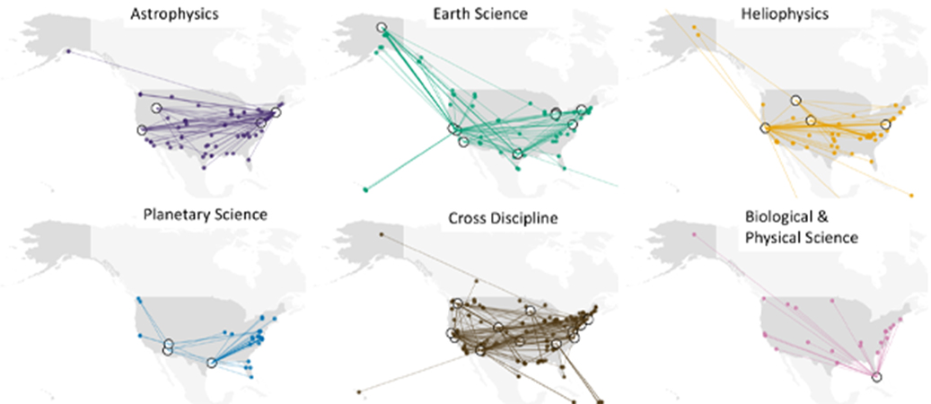
Photo 3. Participants look at the results of a hands-on activity, one of the many types of SciAct resources and...
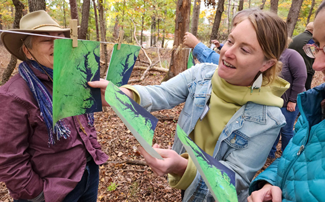
Figure 5. Since the start of 2021, more than half of the SciAct teams have focused their efforts on broadening...
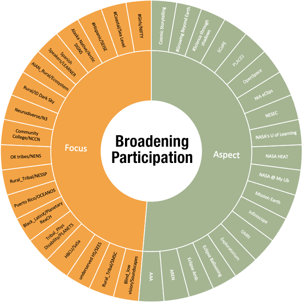
Figure 4. Histogram of citations for SciAct publications as of Oct. 31, 2023. Figure credit: Lin Chambers
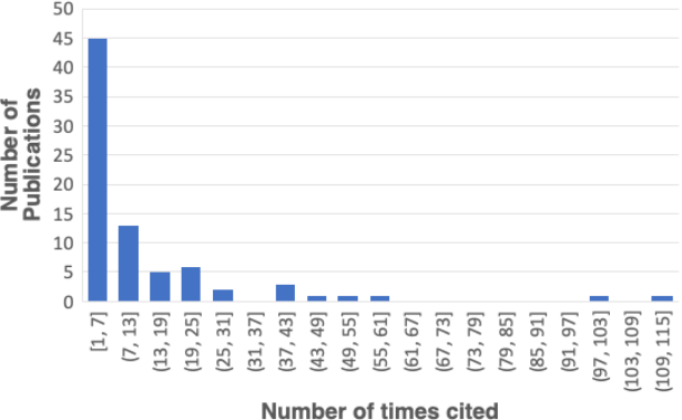
Photo 2. Participants work on the concept of stellar spectra with guidance from a NASA subject matter expert. Photo credit:...
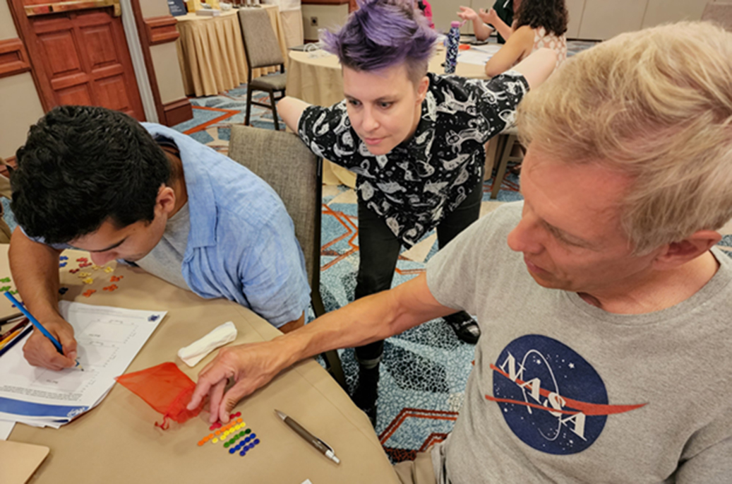
Figure 2. This map shows locations where the SciAct teams conducted various learner interactions across the lower 48 states and...
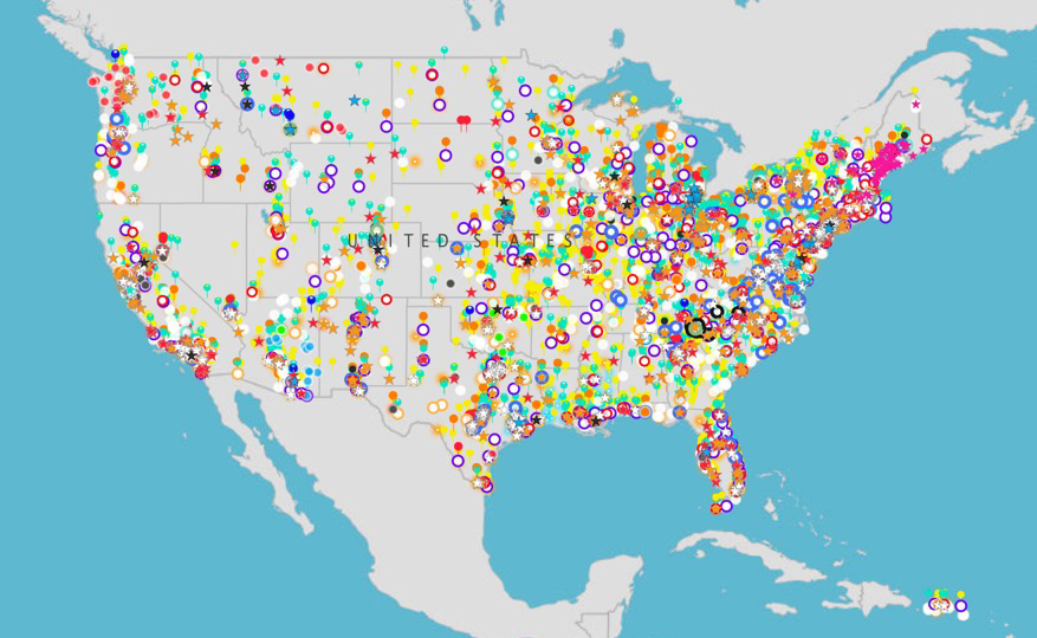
Photo 1. The SciAct community gathered for its most recent annual meeting in November 2023. Photo credit: NASA


Photo. NASA’s Plankton, Aerosol, Cloud, ocean Ecosystem (PACE) spacecraft, atop a SpaceX Falcon 9 rocket, successfully lifts off from Space...
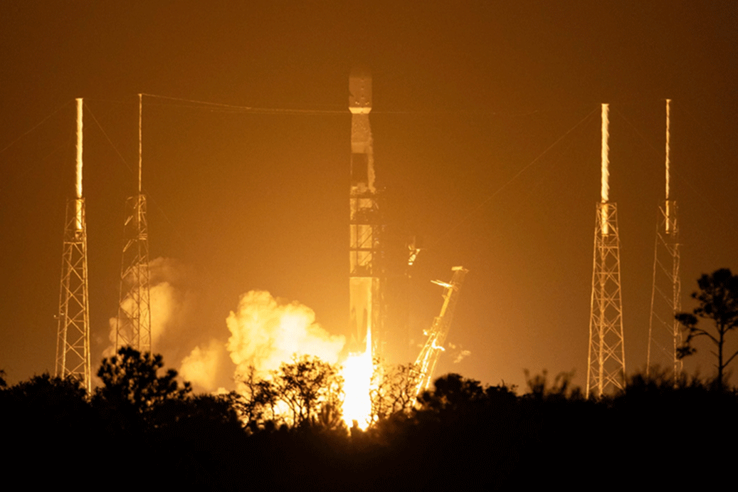
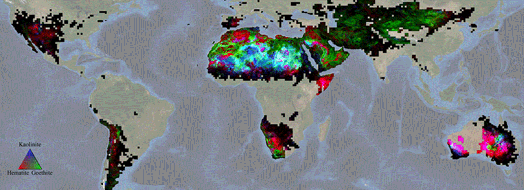
Figure. NASA’s Earth Surface Mineral Dust Source Investigation (EMIT) mapped hematite, goethite, and kaolinite in North Africa and the Arabian...
