VIPER Lunar Operations
VIPER's Mission Operations
For the Volatiles Investigating Polar Exploration Rover, or VIPER, the lunar environment poses unique challenges alongside the rewards of discovering water and other resources as NASA seeks to establish a long-term presence on our nearest neighbor.
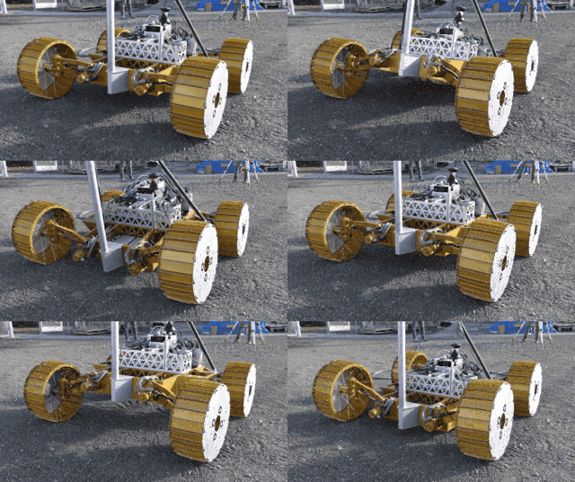
Operated interactively in near-real time by a NASA team back on Earth, the rover must navigate across the rugged terrain of the lunar South Pole while surviving ever-changing extremes in lighting and temperature and periods of communication blackouts. This scenario requires complex and dynamic route planning and waypoint driving to maximize the science return, while keeping the rover in good working condition until the end of its approximately 100-day mission.
Route Planning: Safe, Efficient Traverses
Similar to planning a road trip, VIPER's route planners are designing itineraries that have the rover hitting a number of highlights while attending to the practical needs of traveling in a new place. Using satellite images from NASA's Lunar Reconnaissance Orbiter, a team at NASA's Ames Research Center, where the VIPER mission is led, are examining two-week routes, or traverses. During each, the rover will drive safely and efficiently to spots where it can prospect for ice and then reach a “safe haven” in time to park during periods when the rover loses its direct line-of-site radio communications with Earth. To get the most out of this mission, a host of unique factors must be juggled by addressing these questions:
- Where is there likely to be water frozen in the lunar soil, and how deep does it go?
A higher amount of hydrogen detected in the ground from orbit is a sign of potential water, or H2O. VIPER is tasked with exploring and comparing terrain that is more or less likely to hold water. Maps showing observed hydrogen concentration help plan traverses. While scientists already know there is ice in permanently shadowed craters, a big mystery for VIPER to resolve is whether ice is present, and in what quantities, at and below the surface in areas that receive short periods of sunlight – expanding the known range in which water is present on the Moon.
- How will VIPER keep its solar-powered batteries charged?
Similar to the summer in far northern countries when the Sun hangs low on the horizon, the Moon's South Pole may only see the Sun reach as high as 10 degrees above the horizon. These lighting conditions result in long, fast-moving shadows that sweep across the surface, threatening to plunge the rover into darkness. Visualizations of the movement of these shadows across the landscape help the team plan traverses that have the rover retreating from this threat to keep its solar panels in the light. Meanwhile, the rover must reserve enough power to venture into the depths of dark craters – the most promising spots to find ice – and make it out "alive."
- How will the rover safely navigate the lunar terrain?
Navigating safely and efficiently across the Moon's crater-pocked landscape is a must. VIPER can generally drive on a slope of up to 15 degrees. It can tackle a slope of 25 or 30 degrees when necessary, but the likelihood of slipping increases and slows the rover down. Taking in those constraints, the rover's drivers also use hazard cameras to avoid large rocks and other obstacles that could damage the rover's components.
- How will the rover stay in communication with Earth?
As there are no satellites currently orbiting the Moon that could be used to relay communications, VIPER relies on NASA’s Deep Space Network to send data and receive commands. To maintain a direct-to-Earth radio link, the rover must remain in view of the planet during active roving time and avoid any features in the landscape – such as high mountains or steep crater rims – that would block its communication.
- How will VIPER stay safe during the communications blackouts?
Earth dips out of sight completely for two full weeks a month as the Moon's wobble, called libration, causes its pole to shift out of view of our planet. During this time, communications with the rover is impossible. VIPER must wait out the silence by hibernating in identified locations called “safe havens.” These are points on the terrain high enough that slivers of sunlight can still reach the rover's solar panels and keep the batteries charged so that heaters can keep internal components from freezing. The locations must be planned carefully, as the rover cannot endure more than 50 hours of continuous darkness.

Waypoint Driving: Moving Step by Step
The Moon's proximity to Earth enables flexible, near-real time command and control of the rover. Unlike Mars missions, where the time from sending a command to seeing the results ranges from 10 to 20 minutes, VIPER's latency will be a mere 6 to 10 seconds.
Instead of uploading a long sequence of commands for the rover to carry out alone, drivers on Earth tell VIPER to move incrementally to stops, or waypoints, about every 15 feet (4.5 meters). With this waypoint-driving regime, the rover's speed tops out at about 4 to 9 inches (10 to 20 centimeters) per second when traveling to a pre-planned destination, and slows to 2 to 4 inches (5 to 10 centimeters) per second – about the speed of a giant tortoise – during science operations when VIPER searches for ice in the soil.
The drivers rely on the rover's navigation and hazard cameras to send back images of its immediate surroundings to generate hazard maps that are used to drive a safe course from the ground. Each waypoint is chosen based on the clearest path visible ahead and the drivers' predictions about the rover's mobility on that terrain.
Given the short communications latency, some of the rover's “smarts” do not have to be on board but can instead run at mission control and take advantage of the power and storage capacity of ground computing. For example, images from the rover's navigation and hazard cameras are processed at mission control to generate hazard maps. These maps are then used by drivers to plan a safe course from waypoint to waypoint.
Ten drivers, chosen from the teams that designed and built VIPER at NASA's Ames Research Center in California's Silicon Valley and NASA's Johnson Space Center in Houston, will train for more than a year for this critical role, primarily using high-fidelity simulations of driving on the Moon.

VIPER's Mission Control: The Mission Operations Center
The VIPER Mission Operations Center, or MOC, at Ames, is the primary operations center for VIPER, with support from NASA colleagues in Houston and Florida. The VIPER mission will run 24/7, with three shifts of eight hours, plus a one-hour handover period between the shifts. To help team members stay informed about mission activities during their off time – and encourage them to get some rest – the mission has a new mobile phone app providing data access wherever they are.
Among the many essential roles at the MOC are the drive team, consisting of the driver and co-driver who analyze VIPER's position and path ahead before sending driving commands, and the science team contributing to decisions when the rover is collecting data at a location.
Members of the engineering team focus on the rover and its systems: software at Ames and hardware at the Rover Operation's Support Center based at Johnson.
On the science side, each of VIPER's three instruments and its drill have dedicated team members sending commands to their device on the Moon. In a co-located space at the MOC, called the Mission Science Center, VIPER's team of scientists listen in on the activity from the MOC and report on VIPER's progress on the Moon, as do the instrument teams operating out of rooms at Ames and NASA's Kennedy Space Center in Florida. By analyzing the data and images the rover sends back, the science and instrument teams inform how the science and exploration activities should proceed.
For example, the rover might spend 20 hours at a mission area, drilling for samples in two planned locations and one additional location that the science team chooses based on real-time data coming from the rover.
Software: Creating and Building on Open-Source Code
With all the incoming data from the rover, the MOC team makes use of a web-based data visualization platform developed by NASA called Open Mission Control Technologies. The Open MCT software is open source, making it freely available not only for space missions like VIPER, but other applications in the public and private sectors. It is one of the innovations VIPER is contributing to the emerging space economy and elsewhere by making its capabilities available for companies to use. This software has already flown on several operational NASA missions, and was developed in collaboration with the Advanced Multi-Mission Operations System at NASA's Jet Propulsion Laboratory in Pasadena, California.
Collaborations with industry are also feeding into key aspects of VIPER's software operating system. Rather than creating only custom code, the rover's flight and ground-based software will make extensive use of open-source software, including key components adapted from the Robot Operating System 2 (ROS 2) which is widely used in everything from robot vacuum cleaners to autonomous drones and self-driving cars. Once the mission is over, the VIPER team intends to release the rover's software for general use. This approach allows for a rapid, agile, and cost-effective way of developing the rover's software systems that can also benefit future rovers on the Moon and beyond.
